
27 BEST Hikes on the North Island of New Zealand (for all levels!)
New Zealand is made up of two islands – the North Island and the South Island. The South Island receives the most hype as it’s very mountainous and incredibly beautiful. Its coastline is rugged and wild and within its interior, you’ll find alpine lakes, incredible waterfalls, and mountain peaks. In fact, those views stole my heart and I eventually just had to live there. However, that doesn’t mean I don’t love the North Island!
The North Island is equally as pretty in its own way. With magnificent beaches, stunning bays, and unique volcanic attractions, it’s no wonder I love hiking on the North Island so much.
There are so many amazing hikes to choose from on the North Island. To be honest, it was a difficult task narrowing it down to just 27 hikes.
In this blog, I’ll tell you about the best hikes on the North Island. Each one varies in length, difficulty level, and of course, traverses the different landscapes that make New Zealand such a popular place to hike.
Here are the 27 best hikes on the North Island of New Zealand broken down into smaller regions so that you can easily plan your trip!
Don’t have time to read the full article? Let me help narrow down your choices– here are my top 5 North Island hikes!
- Cathedral Cove is a popular hike on the Coromandel Peninsula (I also love kayaking here!)
- Take on “the world’s greatest day hike”, the Tongariro Alpine Crossing!
- Mount Maunganui is short, sweet, and has amazing panoramic beach views!
- Short on time? Check out Mt Eden and all of Auckland’s volcanoes without leaving the city.
- Explore Northland on the Te Paki Coastal Track, either as a single-day or multi-day hike.
- North Island Hikes Map
- Hikes on the Coromandel Peninsula
- Hikes in Northland
- Hikes in Auckland Region
- Hikes in Bay of Plenty
- Hikes in Gisborne Region
- Hikes in Manawatu-Wanganui Region
- Hikes in Hawke's Bay Region
- Hikes in the Taranaki Region
- Hikes in the Wellington Region
- Thanks for reading!
- Let me HELP you plan your road trip!
- Have a question?
- Why I Book Tours with Viator
- Renting a Car, Campervan, or Motorhome in New Zealand
- Car
- Campervan
- Motorhome
- AIRALO e-SIM Up To 15% Off With Code "DTRAVEL15"
- What’s an eSIM?
- Let me HELP you plan your road trip!
North Island Hikes Map
The above map shows where all of the best hikes on the North Island are located. This way, if you’re driving around New Zealand in a motorhome or campervan, you can easily plan your route around these hikes.
Hikes on the Coromandel Peninsula
1. Cathedral Cove Walk

Important Information: Cathedral Cove has now reopened as of December 2024, following its closure due to land instability and rock slides. You can check here for further updates.
One of the most famous hikes on the North Island is the stunning walk to Cathedral Cove. This 5-kilometer (3.1-mile) return trail begins in the small but cute town of Hahei on the Coromandel Peninsula (the perfect place for a romantic getaway in NZ!). Made famous by the Chronicles of Narnia films and the fact that the rock formation is simply stunning, this hike is a must-do!
The trail is considered easy and although there’s some elevation gain it’s very mild. All up it takes around 45 minutes to walk the trail each way, but you’ll want to allow an hour or two to enjoy Cathedral Cove and the beaches nearby.
Parking at the trailhead is not possible, however, nearby houses charge $10 for the day. Otherwise, you can take a shuttle from Hahei for $7 for adults and $4 for children. This includes your return trip too. I myself always pay someone who lives nearby simply for convenience.
Please Note: Cathedral Cove does occasionally experience closures due to landslides and severe weather (this includes the parking and shuttle as well). However, this doesn’t mean you can’t explore the cove still! There are a ton of tours offered right from Hahei Beach, such as this kayaking tour. This is perfect for those looking for a bit of an adventure and a way to get active.
You’ll spend three hours with a local guide kayaking from Hahei Beach to Cathedral Cove and other sea caves. During this time, you’ll see a lot of marine life, like stingrays, colorful fish, and dolphins. They will provide all kayak equipment, your knowledgeable guide so you can learn all about the area, and snacks in the cove. I love kayaking tours, so if you do too you can book this one for $169 NZD!
Exploring Cathedral Cove is easily one of the best things to do in New Zealand so don’t miss it!
2. The Pinnacles Lookout Track

The Pinnacles Walk is a very popular day and overnight hike on the Coromandel Peninsula. In fact, it’s one of the best things to do in the entire Coromandel region! The trail begins at Kauaeranga Road End car park, which is 9 kilometers (5.6 miles) from Kauaeranga Valley Visitor’s Centre. It is 7 kilometers (4.3 miles) each way to the summit via the Webb Creek Track.
Although rather short, the trail involves some scrambling and the use of ladders. Because of this, it takes at least 3 hours each way and is suitable for intermediate-level hikers. Along the way, you’ll pass the Pinnacles Hut (1 kilometer from the summit.) If you have an advanced booking you can spend the night here and enjoy the Pinnacles view the next morning at sunrise from the summit. At the top, the views are spectacular!
If you don’t have a booking at the hut, you’ll need to hike back down that day. But, I recommend taking the extra time for an overnight, especially if you’ve never stayed in one of New Zealand’s backcountry huts!
On the way down you have the option of going back the way you came (the shortest option) or taking the slightly longer trail to your left past the Billy Goat Campsite. I myself always take the second option simply because the views are different. Not to mention, if you didn’t get a spot at the hut you can always camp here if you’re craving an overnight adventure.
Overall, I’d say the Pinnacles Lookout Track is a really good overnight adventure but be sure to book the hut in advance because this trail is very popular!
Related Read: Check out the 40 best hikes on the South Island too!
3. Mt Paku Summit Walk

The Mt Paku Summit Walk is without a doubt one of the shortest trails on this North Island hikes list. In fact, the trail is only a 2-kilometer return (1.2 miles) and takes around 50 minutes to complete.
Starting just outside the town of Tairua the trail is rather steep and ascends a volcanic peak that used to be an island around 6,500 years ago. Nowadays, the volcano is dormant and lots of locals live below it.
The trail to the top begins at the parking lot below the summit and you’ll walk through a suburban area before you reach the actual trailhead. From here it’s a steep climb to the top, but once there, you’ll be welcomed with 360-degree views of the Coromandel. There are even a few plaques at the top pointing out the nearby islands.
During rain, the trail can be slippery so you may want to avoid it. Also, please be careful where you park as the locals prefer visitors to use the parking lot and not the street. There are signs where parking is not permitted.
Hikes in Northland
4. Te Paki Coastal Track

If you’re looking for epic hikes on the North Island of New Zealand, this is one of the best! This stunning 48-kilometer coastal track (28.9 miles) passes the famed Cape Reinga Lighthouse – the Northernmost point of the North Island. Typically hikers allow 3-4 days to complete the Te Paki Coastal Track. Along the way you can camp at DOC campsites – you just need to carry your equipment with you.
The track follows along the coast from Spirits Bay past Cape Reinga and ends at Te Paki Stream. You can hike the whole track or just do sections of it. These sections vary in length from 45 minutes to several hours and below you can see the most popular:
- Spirits Bay – Pandora: 9 km (5.5 miles)
- Pandora – Tapotupotu Bay: 9 km (5.5 miles)
- Tapotupotu Bay – Cape Reinga: 5 km (3 miles)
- Cape Reinga – Te Werahi Beach: 2 km (1 miles)
- Te Werahi Beach – Twilight Beach: 7.25 km (4.5 miles)
- Twilight Beach – Te Paki Stream: 11 km (7 miles)
The DOC website breaks down each trail and is what I usually refer to when I’m looking for the technical details of the hike (start locations and trail specifics). Keep in mind that sections of the track can be closed at various seasons due to weather, so be sure to check the alerts before you go!
No bookings are required to hike the trail and all campsites are on a first come first serve basis costing $16 NZD for adults and $8 for children. Should you take on the whole track keep in mind it is an advanced tramping track.
You can even book transfers through Real Far North Tours! You can start at one point of the trail, and end on the complete other side and coordinate transportation. Reach out to the company via email and they are more than happy to assist with your hiking adventures.
5. Mangawhai Cliff Walkway

The Mangawhai Cliff Walk is a 2-3 hour return track that starts just outside the small coastal town of Mangawhai. The hike takes you from the shoreline to the cliff tops in Mangawhai with stunning views over the ocean. On the coastal stretches, keep your eyes peeled for whales and dolphins!
On the walk, you will pass through farmland, native bush, and unique rock formations. Have your camera ready to snap the fabulous scenery including the Hen and Chicken Islands, the Hauraki Gulf as well as the Great/Little Barrier Islands at the many viewpoints along the way.
This track starts from near the Mangawhai Head Beach parking lot and is rated as moderate so it is suitable for children. Just keep in mind, it is quite steep in parts and there are many steps to climb.
This is overall a really underrated hike on the North Island and those traveling Northland should make a couple of hour stop to hike it!
Related Read: Less than an hour away from here are more great hikes (and incredible beaches) in the coastal city of Whangarei!
6. Duke’s Nose (Kaiaraara Rocks) Track

Those looking for an off-the-beaten-path hike in Northland shouldn’t look past Duke’s Nose Track. This short 35-minute each-way trail (500 meters) is considered relatively easy up to the final 10 meters which is very steep (you are literally pulling yourself up to the summit with a rope). Along the way, you’ll enjoy spectacular views of Whangaroa Harbour throughout the hike.
The track starts behind Lane Cove Hut in Whangaroa Harbour and at the beginning, you’ll follow a stream behind the hut towards the top of Duke’s Nose. This section of the track can be very slippery after wet weather so be sure to wear appropriate footwear.
Unfortunately, without a boat, you’ll need to reach the start of the Duke’s Nose Track via the Wairakau Stream Track which is a 5.6-kilometer (3.5 miles) one-way trail that begins at the end of Wairakau Road in Totara North. That means you’ll need to walk 12 kilometers (7.5 miles) return to complete this track.
Another option is to turn this trail into an overnight hike by staying at the Lane Cove Hut. You can book the hut in advance and it costs $25 NZD for adults and $12.50 for children. There are basic facilities at the hut and 16 bunk beds.
7. Bay of Islands Coastline Walk

The Bay of Islands Coastline Walk follows the coast all the way from the town of Paihia to Russel (or vice versa) in the Bay of Islands. This gorgeous hike passes a section of the Bay of Islands, along beaches and bays, and through beautiful reserves.
Hiking the full trip involves starting at Paihia and walking along the shore to Opua where you’ll catch the ferry Okiato. From Okiato, you’ll walk through stunning reserves and beaches before finally reaching Russell. From Russel, you can catch the ferry back to Paihia.
All up, the entire loop should take around 8 hours including time to travel on the two ferries required to make the full loop. Although a bit long around 14.7 kilometers (9 miles), the trail is flat so it’s rated as easy. You can also choose to only hike one-half of the trail such as the most popular section from Paihia to Opua, called the Paihia to Opua Walkway. With that said, the full loop is well worth your time.
While you’re in Paihia, I recommend staying for a few days to explore! One of the most popular things to do in Paihia is to see the Hole in the Rock, which is an impressive rock formation on Motukokako Island. Taking a boat tour is a fun way to experience the outdoors, without hiking all day! You’ll get to see the bay’s 144 islands up close, as well as wildlife and the beautiful turquoise water.
I love exploring Paihia, whether that’s taking a goregous coastal hike or exploring the Bay of Islands on a boat!
Related Read: Opua is one of the best stops on the drive from Auckland to Paihia in the Bay of Islands, so rent a car in Auckland and get ready for a super scenic road trip!
8. St Paul’s Rock Trail

If you want to get epic views of the Bay of Islands then you need to hike the St Paul’s Rock Trail in Whangaroa. The trail is rather unknown to tourists and to be honest, I’m not sure why. It’s easily one of the best things to do in the Bay of Islands.
The trail, which involves some scrambling as well as the use of ladders and chains, takes around 30 to 45 minutes to reach the top depending on your fitness level and experience. It’s short and sweet but very steep! In total, this trail is about 720 meters (0.5 miles) each way, but gains 100 meters in elevation- I’m not kidding when I say it’s steep!
Once at the top be sure to take your time and enjoy the 360-degree views of the small islands and bays – it’s a rather sketchy climb down the way you came.
The trail begins on Old Hospital Road near the town of Whangaroa. If the parking lot is full you can park down the road on the street. There are also a lot of beautiful hotels in the area if you want to stay somewhere away from the crowds.
Hikes in Auckland Region
9. Mount Eden Volcano Walk
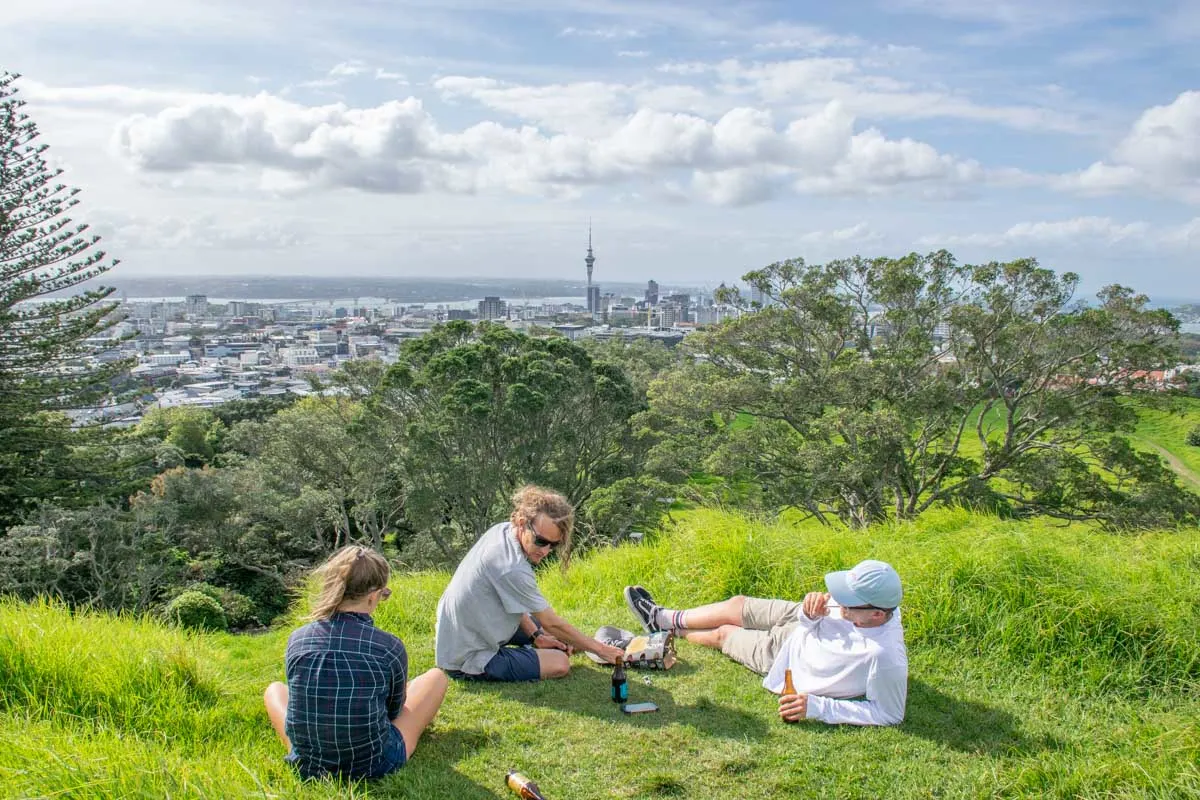
Located a quick 5 kilometers (3 miles) from Auckland CBD is this short but steep walk that takes you to the top of Mount Eden – the highest volcano in Auckland. But don’t worry it’s not an active volcano, in fact, the last eruption was over 15,000 years ago! At the summit, you will be treated to 360° views of Auckland and you can also admire the 50-meter deep volcano crater.
The Mt Eden Volcano Hike will only take about 20 minutes each way. To reach Mount Eden you can either take public transport using this route or drive and park at either the Puhi Huia Road parking lot (corner of Clive Road) or Whau Café. There is even limited parking at the top of Mount Eden, so if you are unable to hike you can still enjoy the views!
If you want to experience more of Auckland’s grand volcanoes (yes, there are more than one!), you can take a half-day or full-day volcano tour. This is a great option if you don’t have your own vehicle, it’s your first time in Auckland, or if you’re eager to learn about this fascinating geological area, all while seeing the stunning sights!
The half-day tour lasts for 5 hours and includes summit walks at Mount Wellington, Mangere Mountain, One Tree Hill, and of course, Mount Eden. The full-day option hits those stops, as well as notable Auckland City sights such as Lake Pupuke and North Head Historic Reserve. You can book the half-day option for $120 NZD per person and the full-day tour for $240 NZD.
10. Whatipu Caves Track and Omanawanui Track

If you’re looking for an easy day trip from Auckland, the Whatipu Caves Track is a short 3.1-kilometer (1.9 miles) return track that passes numerous old sea caves around a 1-hour drive from Auckland CBD. The caves have a fascinating history and would you believe one of the larger caves was once used to host formal dances in the early 20th century?!
The views along the track look over the swampland and the black sand of Whatipu Beach. The cave itself is also very interesting and something different from the other hikes on this list.
While walking through the cave be sure to wear weather-appropriate footwear and be aware that sometimes there will be a few inches of water on the bottom of the cave. You can park your vehicle at the Omanawanui Track parking lot and the trail is well signposted from there.
If you have time, I recommended also hiking the Omanawanui Track. It is a scenic hike (as you can see above) that’s 4 kilometers (2.5 miles) out and back. The trail takes you high up above the beaches below and it’s even better at sunset! This truly boasts the grand beauty of North Island hikes.
Important: Make sure to carry a torch so that you can see inside these caves. Please note – during periods of heavy rainfall the caves should be avoided.
Let me HELP you plan your road trip!

I’ve created this FREE e-book that is your COMPLETE GUIDE to planning a road trip in NZ! In the guide, you’ll find many different road trip itinerary ideas, so you can easily choose one that works for you!
The guide includes the best stops, attractions, road trip routes, and how much time you need!
11. Auckland Foreshore Heritage Walk

The Auckland Foreshore Heritage Walk is a 5-kilometer (3.1-mile) route that starts in Point Erin and ends at Parnell Baths right in downtown Auckland. It’s convenient no matter where you’re staying in the city! On the walk, you’ll pass 25 important sites and information boards that showcase past and present Auckland – it’s one of the top attractions in Auckland!
This track passes through many parks and reserves, old shipyards, beaches, heritage-listed industrial buildings, and much more! It’s a great way to get an insight into the history of Auckland. Plus, you can stop off and enjoy Auckland’s many excellent cafes and restaurants along the way.
If you’re looking to dive deeper into all things Auckland during your stay, I recommend taking this scenic day tour. With all the walking and exploring you’ll be doing during your 8 hours, it’s basically an urban hike! The local guide will take you to the North Head Historic Reserve, Auckland Domain, Mount Eden, and so much more. It even includes wine tasting at Soljans Estate Winery, which is easily my favorite Auckland winery!
I love taking city tours whenever I’m in a new place because it gives me a greater appreciation for the city and helps me navigate it during my remaining days. You can book this tour for $210 NZD per person.
Hikes in Bay of Plenty
12. Orokawa Bay Track
This short walk (just 45 minutes each way) takes you from Waihi Beach to the gorgeous Orokawa Bay. On the walk, you will be treated to ocean views and lush native bush. There are even several historic pā sites (old Maori villages) and gold mining tunnels along the track.
To reach the Orokawa Bay Track, head north along Waihi Beach. The track follows the coastal headlands before heading down into the bay. This track is 6 kilometers (3.7 miles) and only has 207 meters (680 feet) of elevation gain, so it’s a rather moderate trail.
If you want to do a slightly longer hike then continue onto William Wright Falls (another 40 minutes further from Orokawa) or Homunga Bay (another 2 hours from Orokawa).
13. Kaiate Falls

The 60-minute return track to Kaiate Falls gives you the opportunity to see beautiful cascading waterfalls, rock pools, and the lush native bush. Located just 20 minutes from downtown Tauranga, this is one of my favorite stops on the drive from Tauranga to Rotorua!
The Kaiate Falls trail starts from the parking area and follows a figure-8 loop track. It begins by heading to the upper falls, then loops back downhill to the larger lower waterfall. There are lots of steps on this track that can get very slippery so please be careful and wear appropriate footwear.
This track is rated as moderate, however, I consider it easy as it is roughly 2 kilometers (1.25 miles) in length.
Please note you should not swim at the falls due to the high risk of microbial infection. That’s the last thing you want to deal with when you’re on vacation!
14. Mount Maunganui Summit

In my opinion, no visit to the Bay of Plenty is complete without visiting Mount Maunganui. While here be sure to take on the Mount Maunganui Summit Track which is in fact New Zealand’s single most popular walk. This is also a great day trip from Tauranga!
This epic hike takes you to the top of Mount Maunganui (which is an extinct volcano). If you have a reasonable level of fitness the hike to the top is well worth the climb and takes around about 45 minutes each way.
Although steep, the panoramic views at the top are outstanding. Standing at the top of the 232-meter (761-foot) high summit you will see the Western Bay of Plenty, Pāpāmoa, Tauranga, Matakana Island, and Waihī Beach. There are a few different ways to the top but the main one is the Mauao Summit Walk.
My favorite way to celebrate finishing a hike is by stopping off for a pint of craft beer. Be sure to check out Mount Brewing Co.!
My recommendation for people visiting the Tauranga area is to stay in Mount Maunganui. It’s just a much more beautiful area with access to stunning beaches.
Hikes in Gisborne Region
15. Mount Hikurangi Summit

If you’re looking for a challenging back-country hike with a huge payoff, Mount Hikurangi Summit will blow your mind!
This 7-hour one-way track is quite difficult and is considered an expert-level hike. Mount Hikurangi is in fact the highest non-volcanic mountain on the North Island. You’ll get to experience classic New Zealand green rolling hills, sheep farms, and impressive mountain peaks. This track is stunning, to say the least!
The first section of the track follows a well-sign-posted 4WD road that takes you through farmland until you reach the hut. This section should take about 4 – 5 hours depending on your fitness level. The hut needs to be booked in advance by contacting Te Runanganui o Ngati Porou and costs $15 per person. It’s recommended to stay at the hut if you want to hike the summit because of the difficulty of this track.
The second section is marked by poles from the hut up to the mountain summit. It’s not too difficult except for the last 400 meters (0.25 mile) which is not maintained and is a steep scree slope. Hike this section at your own risk.
Around two-thirds of the way up stands nine whakairo (Māori carvings) showing Māui and his whānau or family. This is one of the highlights of the trail and many people turn back here.
The track starts 25 kilometers (15.5 miles) from Ruatoria. Turn off SH 35 onto the Tapuaeroa Valley Road and you’ll find the parking lot!
It’s worth noting that the track from the parking lot to the hut is closed every October for lambing season. Also, public access is closed from the 31st of December until the 1st of January each year for the Hikurangi Maunga Dawn Event.
In terms of unique hikes on the North Island, this one is certainly at the top of the list!
16. Cooks Cove Walkway

Cooks Cove Walkway is a 5.8 km (3.6 mile) return track that takes you to Cooks Cove. This is a significant location as Captain James Cook stopped here in 1769 as part of his exploration of New Zealand. The track is filled with information panels about the voyage to Cooks Cove, which makes the whole experience a bit more insightful
The track starts in Tolaga Bay and travels through native forest. After about 20 minutes of walking, there’s an excellent viewpoint of Cooks Cove. The track itself is rated as an easy walking track, but the views are fantastic and you can even go for a swim in the cove at the end! This is an excellent family hike on the North Island.
Cooks Cove Walkway is located at the southern end of Tolaga Bay, 52 kilometers (33 miles) north of Gisborne.
Hikes in Manawatu-Wanganui Region
17. Tongariro Alpine Crossing


Experience what many people call the “World’s Greatest Day Hike”. This 19.4 km (12-mile) hike is located in Tongariro National Park – a UNESCO World Heritage site and one of the most visited national parks in NZ. It should take between 6 and 8 hours to complete and is rated as very hard (trust me on that one!).
On the Tongariro Alpine Crossing, you will spot three volcanic peaks – Ngauruhoe, Tongariro, and Ruapehu. Which is truly unique.
The beginning of the track climbs up to Red Crater. Be mindful that you will be climbing nearly 800 meters (2,625 feet) in altitude and you may feel the effects of oxygen deficiency. So, be prepared!
Those who love the Lord of the Rings movies might recognize Mt Doom and Mordor. This was the spot chosen to shoot those scenes in the movies and when you visit it’s not hard to see why!
The Tongariro Alpine Crossing can be dangerous if you are not fully prepared. Extreme weather, difficult terrain, and the long distances to cover mean many ill-prepared hikers have to be rescued. In winter the trail often claims the lives of keen hikers. Parking at the trailhead is also limited to 4 hours so you need to take an organized shuttle from Taupo or Turangi. Hiking this trail is one of the most popular things to do in Taupo.
If you’re not so confident to tackle this difficult track by yourself, you can hike a portion of it with a guided day hike. This group tour will take off on the Tongariro Alpine Track, which gives incredible views of Mt Ruapehu and Mount Ngauruhoe, just to name a few of the sights! It departs from the national park, so you will need to get yourself there and have all the proper gear, but it’s a great introduction to difficult hikes. This full-day group guided hike can be booked in advance for $342 NZD per person.
And if you prefer a private tour, they offer that as well! This will allow you to move at your own pace and get a personalized experience as you explore the national park. This private tour can be reserved for $683 NZD per person.
The Tongariro Crossing is an epic hike and one of the best hikes on the North Island. It’s certainly one to add to the bucket list!
Did you Know? You can hike the Tongariro Crossing as part of the longer 3-4 day Tongariro Circuit. This hike is a loop, so no shuttle is needed but it is longer (43 km/27 mi) and you will need to stay in huts along the way. The Tongariro Circuit is one of the 10 Great Walks in New Zealand, and as such, is very popular. So you must book the huts well in advance (typically as soon as bookings open each year.)
Why I Book Tours with Viator
Viator is a trusted online booking system for tours around the world! We almost always book our tours using Viator for a couple of reasons:
18. Taranaki Falls Loop

The Taranaki Falls Loop is a lovely 6-kilometer (3.7-mile) return walk in Tongariro National Park that can easily be done in under two hours. The main feature of this track is of course the waterfalls! I highly recommend this track for families or perhaps a beginner hiker looking to explore Tongariro’s vast beauty.
The track starts from the parking lot across just down the road from the Tongariro National Park Visitor Centre. The trail is well-marked and mostly flat with just a few steps to climb. Stunning views of Mount Ruapehu and Ngauruhoe can be seen from the upper loop track.
If you are walking the Tongariro Circuit, you will pass the falls on either your first day or last day (depending on the direction you are hiking the loop).
If you’re looking for a truly memorable way to experience Taranaki Falls and Tongariro National Park, take this 2-hour sunset hike! You’ll start hiking about an hour before the sun sets so you can be at the best viewpoint as the sky starts to turn pink, orange, and purple. Then enjoy a glass of New Zealand wine while you watch the sunset in the most beautiful location possible!
Hikes in Hawke’s Bay Region
19. Lake Waikaremoana Track

Taking 3-4 days to complete and encompassing 46 kilometers (28.5 miles) of unique terrain the Lake Waikaremoana Track is both challenging and awe-inspiring. It is one of New Zealand’s Great Walks – one of only 10 in the country! It is also on my personal favorite New Zealand hikes list!
It is located in Te Urewera Park near the town of Whakatane. The track follows along the shores of Lake Waikaremoana and includes waterfall and cliff views. One of the best views of this hike can be seen from Panekire Bluff – which you’ll come across on your first day of hiking.
It’s been described as more of a wilderness/back-country hike and is ideal for those looking for a challenge. It’s rated as intermediate and there are campsites and huts along the route to spend the night in.
Hiking this trail takes a fair bit of planning so I won’t go into it in too much detail. Instead, check out the DOC website for more information or this great guide by Laid Back Trip.
Related Read: Many of the other Great Walks in NZ are located on the South Island. I personally love the Routeburn Track as well as the Kepler Track (one of the best things to do in Fiordland National Park)!
20. Sunrise Hut
This 5.2-kilometer track (3.2 miles) offers stunning sunrise views (as the name suggests)! The walk to the hut is an easy walk through native bush that should take 2 hours in total and unless you leave super-early, you are unlikely to catch the famed sunrise from the hut. So, I recommend hiking up the day before and staying in the 20-bed Sunrise Hut. You need to book your bed in advance (best to book it as early in the year as possible, it’s quite popular!) The fees are $25 NZD every night except for Saturday which is $30 NZD a night.
This track starts at the end of the North Block Road at the west edge of the Hawke’s Bay region around 1 hour from Hastings.
Hikes in the Taranaki Region
21. New Plymouth Coastal Walkway

In the city of New Plymouth, there’s a gorgeous promenade walk that takes you from the city to the sea. There are numerous access points on this track to choose where to start and end your walk. The track is 12.7 kilometers (7.9 miles) in total.
The New Plymouth Coastal Walkway starts at Hickford Park and follows through farmland to the Waipu Lagoons and down to the coastline before reaching Te Rewa Rewa Reserve. Cross the Te Rewa Rewa Bridge – which is a perfect photo spot for Mount Taranaki in the distance. After this, you’ll come to the popular NZ surfing beaches of Fitzroy and East End.
On the central section of the track, you will see the Len Lye Wind Wand – a 48-meter (157-foot) kinetic sculpture. It’s a truly unique sight! After this, you can choose to go into New Plymouth CBD and enjoy everything this quirky little city has to offer.
Towards the end of the track, you will pass Kawaroa Park and onto the marina, and finally Ngamotu Beach.
22. Pouakai Circuit/Hut

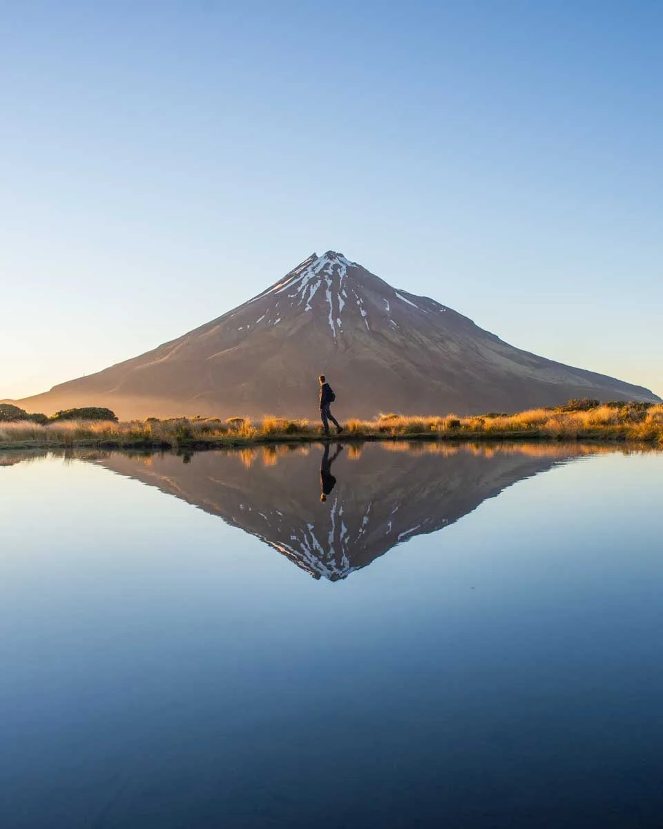
The Pouakai Circuit is a 25-kilometer (15.5-mile) track that starts 30 minutes from New Plymouth CBD at the East Egmont Village parking lot. It takes 2-3 days to complete the full loop. It is a popular hike on the North Island because it loops around Mount Taranaki and the famous top at the Pouakai Tarn. This is without a doubt one of my top hikes on the North Island.
This track was finished recently and it passes through some of the best parts of Egmont National Park/Te Papakura o Taranaki – namely rainforests, alpine tussock fields, the unique Ahukawakawa swamps, and a volcano. You will even be treated to epic views of Mount Taranaki. Along the way be sure to stop for a photo at Pouakai Tarn (pictured above) which is known for having ‘the best view of Mount Taranaki’. On a calm day, the reflections here are mesmerizing and it is easily one of the most beautiful places to visit in New Zealand.
There are DOC huts along the Pouakai Circuit to spend the night (the most famous being the Pouakai Hut) all need to be booked in advance. You can also camp near the huts for free.
For those who don’t want to hike the entire trail, I recommend only hiking up to the Pouakai Hut and back down staying in the hut for one night. This trail is around 2.5 hours each way and gives you plenty of time to watch sunset and sunrise at the Pouakai Tarn only 10 minutes from the hut.
23. Mount Taranaki Summit


If you’re looking for a challenging hike on the North Island then look no further than the Mount Taranaki Summit Track. It is a 6.3-kilometer hike (3.9 miles) up to the summit and returns back down the same way you came – so a total of 12.6 kilometers (7.8 miles). Although not long in distance, the vertical climb is a whopping 1.6 kilometers (almost 1 mile)- it’s a steep trek!
On top of that, the terrain is challenging with kilometers of slippery shale. When I completed this hike I found it frustrating as I tried to climb up and was slipping the entire way. One step up, two steps down is what it felt like. With that said, the way down involved a lot of sliding which was fun!
Climbing to the summit of Mount Taranaki is best done from December to April when there will be less snow. I completed the hike in January and there was still snow at the summit! Those with the right equipment and mountaineering experience can attempt the hike outside of these months, however, I don’t really recommend it.
This hike must be completed in a day as there are no huts or places to camp on the route. It takes most people 6-9 hours to complete it. I love a good challenge and the North Island’s hikes don’t disappoint!
Hikes in the Wellington Region
24. City to Sea Walkway

This 14-kilometer (8.7 mile) track is one of the most popular things to do in Wellington. It is the perfect hike to showcase the beauty of the city and it will take 6-7 hours to complete. I love that it’s an easy escape from the city!
The City to Sea Walkway begins near Parliament buildings and ends in Island Bay. The track takes in famed sights such as the Botanic Gardens and Te Aro Valley. You will also be treated to gorgeous views of central Wellington, Government House, historic Erskine College, the Brooklyn wind turbine, Mount Victoria, Mount Kaukau, and Cook Strait along the way.
It’s really a great introduction to Wellington and hits many of the best attractions in the city.
Another way to see more iconic Wellington sights is to take this city tour. You can see the famous cable car, Mount Victoria, Lady Norwood Rose Garden, the wind turbine, and more! It is led by a local guide, so you’ll get an insider’s perspective of Wellington, which is such a quirky and fun city. You can spend one day hiking the City to Sea Walkway, and another on this tour for a nice balanced experience- book this tour in advance here for $184 NZD.
25. Makara Walkway
Makara Beach is just a 30-minute drive from Wellington CBD, so rent a car in Wellington and make the quick trip out here! This 6-kilometer loop track (3.7 miles) around the Makara Walkway is one of the lesser-explored hikes on the North Island, but with its stunning views and close proximity to Wellington, I’m surprised it’s not more popular.
On the hike, you’ll be treated to epic views as far as the South Island, Mana Island, and Kapiti Island. You’ll also notice wind turbines to the north and the sea-battered bachs that dot the coast. I must admit this is a very photogenic hike – especially on a sunny day.
This hike is one of three hiking spots at the Meridian West Wind Recreation Area. Consider exploring the others if you have time.
26. Red Rocks Coastal Track

Want to enjoy a free wildlife experience in Wellington, New Zealand? Then don’t miss the Red Rocks Coastal Track. Via the short walkway, you’ll explore the area along the coast and spot New Zealand Fur Seals.
The coastline itself is also stunning and your chances of seeing seals are really good. Just be sure to give them plenty of space as this is their home!
You can take a bus from Wellington or drive out to the Red Rocks. They are around 11 kilometers (6.8 miles) from Wellington city center. Their close proximity to the city makes Red Rocks one of the top day trips from Wellington.
If you want to take the bus, catch bus 1 to Island Bay. This will take you around 2 kilometers (1.25 miles) from the rocks and you can walk from there. Bus number 4 does stop closer but it’s unavailable on weekends.
27. Putangirua Pinnacles Track

The Putangirua Pinnacles is another famous Lord of the Rings film location. The tall pinnacles were used as Dimholt Road in the ‘Paths of the Dead’ scene in the Return of the King movie. For any fan of the movies, this is a must-visit!
At the Pinnacles, you can explore a few walking tracks that range in length from 2 to 4 hours, all considered easy. Nearby there is a DOC campsite that costs $6 NZD per person per night.
The Putangirua Pinnacles are located just over an hour from Wellington near Cape Palliser. The only way to get there is by car so it’s best to rent a car in Wellington if you don’t have one.
Although typically visited by Lord of the Rings fans, the trail is beautiful even if you aren’t a fan of the movies and I highly recommend going!
Related Read: Want to know about the best time to visit New Zealand to hike on the North Island? Read my blog for details on the weather, conditions, and more!
Renting a Car, Campervan, or Motorhome in New Zealand


Let’s face it, you’re going to need wheels to get around New Zealand. Although a small country, buses between destinations are infrequent and expensive. Plus, some of the best experiences you can have in NZ are on road trips!
You have three options when it comes to getting wheels in New Zealand: a car, a campervan, or a motorhome. Here’s what you need to know about each and where to get them:

Car
A normal car is the cheapest rental vehicle you can get in New Zealand. It’ll get you around to all of the best destinations with ease. The only downside to a car is that you will need to stay in hotels or Airbnbs during your travels (no camping, unless you buy a tent!). My favorite place to rent a car in New Zealand is Snap Rentals. They are a local company that offers affordable and high-quality rental vehicles across the country. Plus, I have an exclusive discount that gets you 10% off when you book through this link or use the code MQD10 at checkout! And if you can’t find what you’re looking for on Snap Rentals, check out Discover Cars, where you can compare cars and prices across many different companies.

Campervan
A Campervan is a large van that has a bed and a small kitchen in the back. It’s what most budget travelers use for traveling around New Zealand since it allows you to camp comfortably and for free (most) nights. Campervans are best for couples or solo travelers who are happy to live in a small space. You should also love the outdoors and camping…and be prepared for an adventure of a lifetime! My favorite campervan rental company is JUCY because they have a huge selection of campervans to choose from, plus multiple pick-up/drop-off locations. You can browse JUCY’s campervan selection online here. Alternatively, you can easily compare all campervans available in NZ on Motorhome Republic here.

Motorhome
A motorhome is larger and more comfortable than a campervan. Many motorhomes will comfortably sleep 6 or more people – perfect for a family visiting New Zealand. Motorhomes are the most expensive option, but with one, you won’t ever need to stay in a hotel, and you’ll save money that way. My top choice for a motorhome company is Star RV because they have beautiful motorhomes at affordable prices. You can check prices and availability for Star RV motorhomes online here. Alternatively, you can use Motorhome Republic to search all motorhomes in NZ. For more detailed info, read my complete guide to renting a motorhome in New Zealand!
EXCLUSIVE DISCOUNT CODE: I’ve organized a special discount code that will get you up to 10% off if you book your campervan or motorhome through JUCY or Star RV!
Simply click here to select your JUCY campervan, or click here to select your Star RV motorhome, and then use the code DTRAVEL10 at checkout to get 10% off bookings with travel dates up to and including September 30, 2026 (minimum 5-day hire). Traveling outside those dates? No worries—use code DTRAVEL25 to receive 5% off anytime through December 31, 2026 – it’s that easy!
AIRALO e-SIM Up To 15% Off With Code “DTRAVEL15”
What’s an eSIM?
An eSIM is a digital version of a SIM card. Instead of buying a little plastic chip and swapping it into your phone, you just download it. It connects your phone to a local network in whatever country you’re visiting — no stores, no waiting, and no fiddling with tiny cards.
In simple terms, it’s the easiest way to get data and stay connected while traveling.
We’ve tested a bunch of eSIMs in North America, and after a few frustrating experiences, we’ve found our favorite — Airalo. It’s fast, reliable, and incredibly easy to use. You can set it up in minutes (even my mom managed it solo on her first try!), and the prices are some of the best out there.
🔥 Hot Tip: Choose the Oceania-wide eSIM! It works across 8 countries, so you can hop from New Zealand to Australia to Fiji without ever losing connection. One download, endless adventures.
Bonus: We’ve got an exclusive 15% discount for our readers. Use the codes:
Thanks for reading!

The North Island of New Zealand sure has many excellent hikes. Dare I say it’s been one of my favorite places to go hiking! I hope this list has helped you make a decision on what hikes to do on the North Island. If you can, I recommend doing them all!
Thanks so much for reading! If you found this guide helpful then be sure to browse around some more. I have tons of New Zealand blogs including plenty about hiking and also the best time to visit the North Island!
33 Cool Things to do on the North Island of New Zealand
15 Perfect Romantic Getaways in NZ
17 Best Stops on the Drive from Taupo to Rotorua
15 BEST Things to do in Whanganui, New Zealand
Let me HELP you plan your road trip!
I’ve created this FREE e-book that is your COMPLETE GUIDE to planning a road trip in NZ! In the guide, you’ll find many different road trip itinerary ideas, so you can easily choose one that works for you!
The guide includes the best stops, attractions, road trip routes, and how much time you need!


Thank you for your great article about trail in NZ!
I will be staying in Auckland until mid of August.
So I will try some trail!