
40 Best Hikes on the South Island of New Zealand
Are you an avid hiker looking to explore the most challenging hikes the South Island of New Zealand has to offer? Or maybe you’re looking for that perfect, easy trail to walk with your family? No matter your reason for hiking, in this blog, I’ve got you covered!
After road-tripping around the South Island in my campervan and getting in as many hikes as possible, I’ve cultivated quite a list from personal experience. So with this list, I wanted to showcase the absolute best from a range of landscapes, distances, and difficulties.
I’ve reviewed hundreds of trails in order to create this list, and I can safely say that each hike offers something truly special. So, get your New Zealand bucket list ready, here are the 40 best hikes on the South Island!
Important: This list is broken down into smaller regions in New Zealand so you can easily plan your trip. Also, below is a map of all the hikes on the South Island to make planning even easier!
- South Island Hikes Map
- Hikes in Otago Region (Queenstown/Wanaka/Glenorchy)
- Hikes in Fiordland National Park
- Hikes in Mount Cook National Park and Area
- Hikes on the West Coast
- Abel Tasman National Park and Area
- Hikes in the Catlins/Southland
- Christchurch and Arthur's Pass
- Thanks for reading!
- Let me HELP you plan your road trip!
- Have a question?
- Why I Book Tours with Viator
- Renting a Car, Campervan, or Motorhome in New Zealand
- Car
- Campervan
- Motorhome
- AIRALO e-SIM Up To 15% Off With Code "DTRAVEL15"
- What’s an eSIM?
- Let me HELP you plan your road trip!
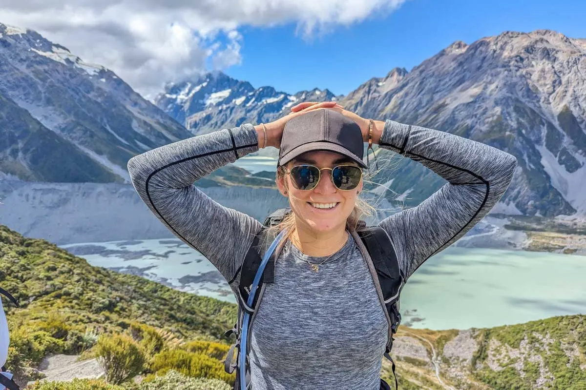
South Island Hikes Map
Hikes in Otago Region (Queenstown/Wanaka/Glenorchy)
1. Queenstown Hill

- Overview: A super fun trail with some epic views over Queenstown and beyond
- Distance: 5 kilometer (3.1 mi) return
- Time needed: 3 – 4 hours
- Difficulty: Easy to moderate
- Starts from: The Queenstown Hill Trailhead
I’m kicking this mammoth list off with a favorite hike of mine in my hometown of Queenstown. The Queenstown Hill Track is a beautiful hike that leads to Queenstown Hill summit with breathtaking views over Lake Wakatipu, Queenstown, and The Remarkables Mountain Range. It’s one hike I absolutely love and easily one of the best hikes on the South Island of New Zealand.
The trail itself is easy/moderate and from the trailhead, it’s only a 5-kilometer (3.1 miles) return hike. With that said, there is a hefty elevation gain of over 400 meters, (1,312 feet). On a good day, it takes me just over 3 hours to finish the hike but that includes a nice long break at the summit!
It’s short, relatively easy, and considered one of the best hikes in Queenstown!
2. Bob’s Cove Track


- Overview: An easygoing trail perfect for any level of fitness!
- Distance: 2 km (1.2 mi)
- Time needed: 30 minutes
- Difficulty: Easy
- Starts from: Bob’s Cove Track parking lot
Bob’s Cove is a gorgeous bay on Lake Wakatipu only 15 minutes from Queenstown on the road to Glenorchy. Although beautiful from the beach, you simply must hike Bob’s Cove Track up to Picnic Point to get an even better view of the area.
Bob’s Cove Track is a short hiking trail that takes only 30 minutes to finish. With that said, the rewarding view on this hike makes it one of the best things to do while you’re in Queenstown. I mean, just check out the picture above!?
Anyone can hike this trail which I love, yet it still remains off-the-beaten-path in Queenstown. So, head up for sunrise or sunset and enjoy the epic viewpoint!
Related Read: Bob’s Cove Track is one of the easiest hiking trails in Queenstown – find out what the others are!
3. Secret Moke Lake Viewpoint

- Overview: A quiet trail with challenging sections, but the views are so worth it
- Distance: 2.9 km (1.8 mi)
- Time needed: 1.5 – 2 hours
- Difficulty: Moderate
- Starts from: Moke Lake Campsite
The Secret Moke Lake Viewpoint isn’t that much of a secret anymore, but it’s still a rather unknown hiking trail only 20 minutes from Queenstown. The trail, which begins from Moke Lake, leads up a steep, unofficial trial to a small viewpoint over Moke Lake. It can be hard to find the “trail” but this guide to the Moke Lake Viewpoint does show you exactly how.
Although it only takes 40 minutes to reach the top, the trail is very steep in some sections. Those afraid of heights or traveling with children should avoid it! But for those who do reach the top, the views over Moke Lake are stunning! It’s easily one of the best things to do at Moke Lake.
Another great activity to do while you’re at Moke Lake is kayaking! The lake is protected from the wind so its calm waters perfectly mirror the surrounding mountains- it’s incredible. Taking a kayak out to explore these serene waters is my favorite way to wind down from a hike on the South Island.
If you don’t have a kayak of your own- no worries! This 3-hour kayak tour from Queenstown provides transportation, all kayak equipment, and a local guide to show you the ropes. This is a unique way to explore Queenstown’s great outdoors, and give yourself a break from all of those South Island hikes! You can book this tour for $169 NZD per person.
4. Tiki Trail

- Overview: A moderately difficult trail that deserves all of its fame!
- Distance: 2.1 km (1.3 mi) each way
- Time needed: 3 hours up and back
- Difficulty: Moderate
- Starts from: The Tiki Trail Trailhead
The Tiki Trail is a hugely popular hiking trail that starts right in Queenstown on Brecon Street at the exact same spot as the Queenstown Gondola. In fact, the Tiki Trail is just the budget traveler’s way of getting up to Bob’s Peak where the famous Skyline Building and Luge are located.
With that said, the trail itself is gorgeous, and on it, you’ll walk among huge pine trees and catch glimpses of Lake Wakatipu and Queenstown below. Of course, the main attraction is the view from the top, and once you see it for yourself you’ll be blown away!
The trail is 2.1 kilometers (1.3 miles) each way and gains 450 meters (1,476 feet) in elevation. It’s a hard hike to the top but it only takes around 1.5 hours. This is how you reach the Ben Lomond Track- which is the next on our list!
The best part is that you’ll save $64 NZD on the gondola and hike one of the South Island’s most breathtaking trails! (Breathtaking because of the views- not the steep track!)
Once you’re at the top of Bob’s Peak, you can hang out for a while! Enjoy the scenic views, grab lunch at the Market Kitchen Cafe, or keep the adventure going and try ziplining or paragliding from the top.
There are some epic ziplines in New Zealand, but the Skyline Zipline is one of my favorites. They are famous for having the world’s steepest drop (21 meters/69 feet), which certainly made my stomach drop- but in a thrilling way! Plus, this means you don’t have to hike back down the mountain! You can choose from a range of zipline options starting at $119 NZD, see all options and book it here.
If you’re up for more of a high-flying adventure, you can paraglide back to Queenstown from the top of Bob’s Peak. Imagine seeing the trail you just climbed from an aerial view! This is a tandem paraglide, so it’s perfect for beginners. You can reserve this paraglide experience for $320 NZD.
5. Ben Lomond Track

- Overview: This hike will test you, but reward your effort with gorgeous views
- Distance: 14 km (8.7 mi) return
- Time needed: 7 hours
- Difficulty: Moderate to challenging
- Starts from: The Tiki Trail Trailhead
When it comes to hikes on the South Island, few are as famous as Ben Lomond Track. The trail starts from Queenstown at the Queenstown gondola and first, you must either hike the Tiki Trail or take the gondola up to Bob’s Peak to begin.
This is a rather difficult hike, but it’s worth it- trust me!
Once at the top, you’ll begin a steady walk to the saddle before making the grueling climb to the summit. All up, it’s a 14-kilometer (8.7 miles) hike with an elevation gain of over 1,400 meters (4,593 feet)! I’d allow at least 7 hours depending on how fit you are.
Remember, if you choose to take the Tiki Trail instead of riding the gondola, that will add 2.1 kilometers (1.3 miles) each way. But, once you’ve gone that far, what’s a few more kilometers anyway!?
With that said, the views at the summit and along the trail are worth every breath! This is possibly the best hike in Queenstown and easily one of the best hikes on the South Island.
Related Read: This epic hike is considered one of the best and should be a part of every 7-day or 14-day South Island Itinerary!
6. Lake Alta Track


- Overview: A quick but relatively challenging hike showcasing a beautiful alpine lake
- Distance: 1.75 km (1 mi) each way
- Time needed: 1.5 – 2.5 hours
- Difficulty: Moderate
- Starts from: The Remarkables Ski Field
Lake Alta sits at 1,800 meters (5,905 feet) above sea level. I know what you’re thinking, a lake that high must be hard to get to! Well, actually it’s not. In fact, the Lake Alta Track is only a 1.75-kilometer (1 mile) hike each way, and the reason for that is that it starts from The Remarkables Ski Field just outside of Queenstown. To hike the trail, you’ll need to enjoy the scenic drive up to the ski field, but once you do, you’re almost there.
The trail is still quite the climb from the ski field, but all up it only takes 2 hours to finish. If you do want to hike further then you can hike up to the saddle above for an epic bird’s eye view of Lake Alta.
Lake Alta Track is not a busy trail on the South Island which has always surprised me, especially since it’s also a Lord of the Rings film location!
While the Lake Alta track is technically open year-round, it’s best completed during the summer, otherwise, it’s difficult to find the trail in the snow. If you’re looking to explore The Remarkables Ski Field area during the winter, you can go on a snowshoeing tour! Snowshoeing is basically hiking in the snow made easier and it’s a fun way to explore during the winter. It’s easily one of my favorite things to do in Queenstown during the winter!
Booking a tour is great if it’s your first time or don’t have the proper gear- you can book this snowshoeing tour for $679 NZD.
7. Earnslaw Burn Track


- Overview: A wilderness adventure that’s not for the faint-hearted!
- Distance: 24.5 km (15.2 mi)
- Time needed: 8 – 10 hours
- Difficulty: Challenging
- Starts from: Earnslaw Burn Track parking lot
Starting just outside of Glenorchy, the Earnslaw Burn Track is one of the best free things to do in Glenorchy. The trail isn’t overly popular, but it really should be. The Earnslaw Burn Track starts with a steady climb through the New Zealand beach forest before climbing higher until you can stare up at the Earnslaw Glacier and Mt Earnslaw.
Unfortunately, if you want to hike the trail in one day, you’ll need to be prepared for a 10-hour backcountry hike. Instead, many people (including myself) opt to spend the night camping near the glacier. It’s honestly a beautiful place to camp (just check out the photo above) and spreads the hike over two days.
This is a hiking trail on the South Island for the more adventurous. So if you consider yourself an experienced hiker, be sure to add this one to your must-do list!
8. Greenstone Track
- Overview: An epic hike that stretches multiple days – so many amazing viewpoints!
- Distance: 40 km (25 mi)
- Time needed: 2 – 3 days
- Difficulty: Moderate
- Starts from: Greenstone parking lot
The Greenstone Track is a multi-day hike in Glenorchy. The point-to-point trail is 40 kilometers (25 miles) long and starts from the Greenstone parking lot near Kinloch, and finishes at The Divide on the road between Te Anau and Milford Sound. The trail’s landscapes are very similar to Routeburn Track and part of the trail actually links up to it.
The hike through the mountains takes around 2 to 3 days, and along the way, you can stay at DOC-serviced huts for $25 NZD per person per night. Bookings are not required for the Greenstone Hut, it is on a first-come-first-serve basis. However, you do still need to pay the fee!
This is considered a moderate track, so if you’re relatively new to multi-day treks, this is a good option for you! As always with multi-day trips, be sure to be well prepared with adequate water, food, and first aid.
Despite not being considered a Great Walk, the views are epic! Plus, it’s a tranquil trail really feels like a backcountry hike. Along the way, you’ll rub shoulders with other adventure enthusiasts while enjoying views of deep valleys, waterfalls, and alpine lakes!
9. Glenorchy Walkway

- Overview: A straightforward trail in Glenorchy that offers some truly gorgeous views!
- Distance: 5 km (3.1 mi) loop
- Time needed: 1 hour
- Difficulty: Easy
- Starts from: Glenorchy Waterfront Car Park
The Glenorchy Walkway is easily one of the best hikes in Glenorchy. The trail starts from the waterfront at the Glenorchy jetty which is a must-visit on its own. The trail then follows the shoreline of Lake Wakatipu before heading inland to the Glenorchy Lagoon.
At the Glenorchy Lagoon, you walk along a boardwalk and on a calm day enjoy breathtaking reflections of the Humboldt Mountains (picture above.) All up, the entire loop is 5 kilometers (3.1 miles) long and takes just over an hour to complete at a steady pace. The Glenorchy Lagoon is also a great place to spot birds. So take your time, enjoy the views, and be sure to bring bug spray for the mosquitos (why do you think birds love it!).
Glenorchy is one of my all-time favorite small towns in New Zealand. Even if you don’t hike the Glenorchy Walkway, you should still consider spending a half-day driving the scenic route from Queenstown to Glenorchy and exploring. You can even book a half-day tour to Glenorchy that takes care of transportation and plans all the scenic stops along the way. Plus, having a local guide helps you dive into the history, culture, and find hidden gems in Glenorchy- you can book this tour for $179 NZD.
10. Roy’s Peak

- Overview: THE most popular day hike on the South Island, and it deserves the crown!
- Distance: 8 km (5 mi)
- Time needed: 6 – 7 hours
- Difficulty: Challenging
- Starts from: Roy’s Peak Parking Lot
If I had to pick the most popular day hike on the South Island, I’d have to choose the Roy’s Peak Track. Don’t get me wrong, others come close, but Roy’s Peak is at the top of everyone’s South Island bucket list.
Don’t be fooled by its popularity, though, Roy’s Peak is a hard day hike. The trail starts just outside of Wanaka and involves an 8-kilometer (5 miles) climb with a 1,300-meter (4,265 feet) elevation gain. It’s tough and relentless the entire way to the summit, which takes around 3 to 4 hours.
Once there though, the views are actually out of this world. You can peer down at Lake Wanaka and the surrounding mountains. It’s common to be above the clouds, which is really cool! Of course, you can also get that famous Roy’s Peak photo.
Don’t get confused though, the famous peak isn’t actually the end of the trail. It’s 30 minutes from the top (my guide about Roy’s Peak Track above tells you everything you need to know!).
If you’re looking for an even more epic Roy’s Peak experience, wake up early (like 3 am early) and bring a headlamp so you can reach the summit for sunrise. Roy’s Peak at sunrise is almost unreal, it is so beautiful!
11. Isthmus Peak

- Overview: A fantastic alternative to Roy’s Peak that offers next-level views
- Distance: 8 km (5 mi)
- Time needed: 4 – 6 hours
- Difficulty: Moderate to challenging
- Starts from: Isthmus Peak Parking
Isthmus Peak is known as the “other Roy’s Peak”. The trail also starts just outside of Wanaka, and although it’s less popular than Roy’s Peak, is still considered one of the best hikes in Wanaka. The trail is slightly easier (only just) than Roy’s Peak with a 1,113-meter (3,652 feet) elevation gain over 8 kilometers (5 miles) one way. But it’s still really hard!
The trail is 16 kilometers (10 miles) long in total and will take 4-6 hours to complete. The trailhead is near the car park. There is a decent amount of parking available, and since it’s not as popular as Roy’s Peak, you don’t have to fight for a spot as often!
The views from Isthmus Peak rival those at Roy’s Peak only you get to enjoy them without the crowds, which I love. Isthmus Peak is perfect for the hiker who really wants to avoid the large crowds that Roy’s Peak attracts.
12. Diamond Lake Lookout Track

- Overview: One of my favorite trails in Wanaka with gorgeous lake views
- Distance: 7 km (4.3 mi)
- Time needed: 2 – 3 hours
- Difficulty: Moderate
- Starts from: Diamond Lake Roadside Parking
If you’re visiting Wanaka and think that Roy’s Peak and Isthmus Peak sound a little too hard for you, then the Diamond Lake Lookout Track is a great option. The trailhead is located 20 minutes from Wanaka near Mount Aspiring National Park. Although the trail isn’t easy, when compared to Roy’s Peak, it’s a breeze!
Diamond Lake Lookout Track involves a gradual climb to a viewpoint above Diamond Lake that takes around 3 hours. The length of the trail is 7 kilometers (4.3 miles) long in total. On a beautiful day, you get amazing views of Lake Wanaka and Diamond Lake from above.
As you can see from the photo above, I didn’t get the best weather, but if you do, the views will be much better! It’s still insanely beautiful with those low-hanging clouds, though!
13. Rob Roy Glacier Track

- Overview: A fun half-day hike with gorgeous views of a glacier
- Distance: 10 km (6.2 mi) return
- Time needed: 3 hours
- Difficulty: Moderate
- Starts from: Raspberry Flat Car Park
If you want to explore beautiful valleys and spot hanging glaciers, then the Rob Roy Glacier Track is a top choice, located just outside of Wanaka. The trail is a 10-kilometer (6.2 miles) return hike with a steady elevation gain of 450 meters (1,476 feet). In total, it only takes 3 hours to hike the trail, so it’s a perfect half-day hike on the South Island.
The views along the way are typical of New Zealand, just imagine blue rivers, tussock grass, New Zealand sheep, and of course that epic view of Rob Roy Glacier (and the waterfalls the glacier creates below!) The trail is popular, so if you plan on visiting in the summer, be sure to set off early!
Note: As of April 2024, the Rob Roy Glacier Track remains closed due to a bridge closure. You can find the latest updates on the DOC website here.
Hikes in Fiordland National Park
14. Routeburn Track


- Overview: A truly epic multi-day trail that will test any seasoned hiker!
- Distance: 32 km (20 mi)
- Time needed: 2 – 3 days
- Difficulty: Moderate to challenging
- Starts from: The Divide Car Park
The Routeburn Track is the first of New Zealand’s 10 Great Walks on this list (don’t worry, more are coming). This 32-kilometer (20 miles) point-to-point trail is hiked in one direction, usually over 2 to 3 days. One end of the trail starts at Routeburn Shelter near Glenorchy, and the other, at The Divide on the road between Te Anau and Milford Sound.
Although the trail is in the Fiordland National Park category, it also passes through Mt Aspiring National Park. On the trail, you get to experience a huge variety of landscapes including rivers, valleys, alpine lakes, mountain peaks, and waterfalls.
To hike the entire Routeburn Track, bookings for the campsites and huts need to be made well in advance. The best part is though, that you can also do lots of great day hikes on the Routeburn Track. You can go on your own or if you prefer a guided experience, you can book either a half-day hike or a full-day guided hike of the Routeburn Track.
This half-day tour provides transportation from Queenstown and will spend 2.5 hours hiking on the Routeburn Track. This is a great option for those who don’t have their own transportation, are new to hiking, or simply want the convenience of a tour! This guided hike is $225 NZD and includes snacks, water, the guide, and transport.
You can also opt for a full-day guided hike from Queenstown. You will hike 6.5 kilometers (4 miles) each way to Lake Wakatipu, following your local guide and learning all about the area. This tour provides transport from Queenstown, snacks, water, stops at scenic viewpoints, and a fun day outside for $340 NZD.
I’ve both hiked the full Routeburn Track and done day hikes, and I never get sick of the views!
15. Lake Marian

- Overview: A gorgeous hike in Milford Sound, worthy of many Instagram pics!
- Distance: 10 km (6.2 mi)
- Time needed: 3 hours
- Difficulty: Moderate
- Starts from: Lake Marian Trail Car Park
Lake Marian Track is my favorite of all the hikes around Milford Sound. I absolutely love the view from the edge of Lake Marian of the surrounding mountains. It’s also the place I went for my first polar dip in New Zealand – it was so cold!
This track is approximately 10 kilometers (6.2 miles) and is known as a challenging route, but is doable in one day.
From the parking lot, it takes around 2 hours to reach the lake and 1 hour to return back down. There is a constant slope until the lake and in total, you’ll climb 400 meters (1,312 feet) in elevation. The trail is not well maintained and you will need to use your hands in some parts as well as be careful of slippery rocks.
You can also see Lake Marian Falls along this track, which is one of my favorite waterfalls on the South Island (see the others here!).
With that said, it’s worth it! If you get great weather the views are mind-blowing and as you sit in that huge valley you feel so small!
Let me HELP you plan your road trip!

I’ve created this FREE e-book that is your COMPLETE GUIDE to planning a road trip in NZ! In the guide, you’ll find many different road trip itinerary ideas, so you can easily choose one that works for you!
The guide includes the best stops, attractions, road trip routes, and how much time you need!
16. Key Summit

- Overview: A wonderful alternative to the Lake Marian Trail, with breathtaking views
- Distance: 3.4 km (2.1 mi) each way
- Time needed: 2 – 3 hours
- Difficulty: Easy to moderate
- Starts from: The Divide Car Park
Another hugely popular hiking trail on the South Island is the Key Summit. This trail is the rival to Lake Marian in the sense that most people only have time to do one, and they’re located down the road from each other.
The Key Summit is a viewpoint trail that has you hiking part of the Routeburn Track before branching off onto the Key Summit Track. The entire Key Summit is steep, but at only 3.4 kilometers (2.1 miles) each way, it takes less than 3 hours in total. It is rated as a moderate to easy hike.
The Key Summit is most famous for its breathtaking views over Fiordland National Park, and on a clear day, you can actually peer down at Lake Marian. There is also a small tarn at the Key Summit where you get stunning reflections of the mountains.
There is an awesome guided tour of the Key Summit from Te Anau. The guides on this hike are phenomenal and make it an immersive experience, for any fitness level! There are only 12 people on this hike, so it’s a fun way to make some friends and enjoy the views. I especially love that it provides transportation from Te Anau (about a 1.5-hour drive) because nothing is more tiring after a long hike than a long drive.
You can book this hiking tour for $260 NZD per person, and for just $5 more you can add lunch! It includes your guide, transportation from Te Anau, water, snacks, and rain gear if necessary- the views are complimentary!
Why I Book Tours with Viator
Viator is a trusted online booking system for tours around the world! We almost always book our tours using Viator for a couple of reasons:
17. Kepler Track

- Overview: I might be biased, but you can’t beat the views on this epic, multi-day trail!
- Distance: 60 km (37.3 mi)
- Time needed: 3 – 4 days
- Difficulty: Moderate
- Starts from: Kepler Car Park
My favorite Great Walk in New Zealand is the Kepler Track! Now, I haven’t done them all, however, out of the 5 I have done, the Kepler was hands down the most spectacular.
The 60-kilometer (37.3 miles) loop track is usually hiked over 3 to 4 days, staying in huts and camping along the way. Most people hike the Kepler in a counter-clockwise direction, and if you do, the trail begins with a steep climb up to Luxmore Hut.
Luxmore Hut is stunning and spending the night there is an unforgettable experience! Afterward, you must walk the entire ridgeline of Luxmore Mountain and enjoy epic views down deep fiords and into the horizon at huge mountain peaks. Next, the trail takes you down the valley where humid forests, lakes, and waterfalls await – it’s breathtaking!
The trail covers so many different landscapes and you’ll almost certainly have an encounter with a cheeky Kea on the Kepler Track!
If that sounds a bit too intense for you, you can hike a portion of the track on this Kepler Track Boat and Hike Tour where you’ll also get to see several Lord of the Rings filming locations on Lake Manapouri as you head to the starting point for your portion of the hike! Plus, you get a thrilling jet boat ride, so it’s a bit of adrenaline added to your adventure! You can check out the details and reserve this tour in advance here.
Related Read: The drive from Queenstown to Te Anau is highly underrated, and contrary to what you might’ve heard, there are actually lots of great places to check out on that drive!
18. Milford Track

- Overview: The rockstar of the 10 Great Walks, this multi-day trail is full of surprises!
- Distance: 54 km (33.5 mi)
- Time needed: 3 – 4 days
- Difficulty: Moderate
- Starts from: Via water taxi from Glade Wharf in the Te Anau Downs
The Milford Track is the most famous of the 10 Great Walks on the South Island. It’s so popular that getting bookings for the huts along the trail could be compared to getting concert tickets – it’s crazy! However, for those lucky few who do manage to snag a booking, you’ll get to experience one of the most diverse and rewarding hiking trails in New Zealand.
The 54-kilometer (33.5 miles) trail takes between 3 to 4 days to complete and begins with a water taxi across Lake Te Anau to reach the trailhead. Then, it’s 4 days of walking through stunning fiords and ancient rainforests until you come out the other side at Sandfly Point in Milford Sound. It’s an epic journey and a once-in-a-lifetime experience!
You will need to book the huts in advance, I explain some of the details in this blog post!
19. Gertrude Saddle Route
- Overview: A difficult but equally rewarding trail with jaw-dropping views
- Distance: 7.4 km (4.6 mi)
- Time needed: 6 hours
- Difficulty: Challenging
- Starts from: Gertrude Pullover Parking Lot
If you’ve ever wanted to stare down into a deep fiord without paying for a scenic flight, then the perfect trail for you is Gertrude Saddle Route. This epic hike is only a 7.4-kilometer (4.6 miles) return hike but you must make a steep climb up to the saddle, which in some places, is actually dangerous.
The views though are out of this world and you’ll be so humbled by the sheer size of the glaciers that carved these fiords. Oh, and did I mention you can see Milford Sound too!?
As I mentioned above, the trail is not suited to young children and you should exercise extreme caution when hiking Gertrude Saddle Route. Never hike the trail in bad weather or in winter, and be sure to research the trail beforehand so you can be prepared!
If you want to talk about the best scenic hikes on the South Island, Milford won’t disappoint!
Hikes in Mount Cook National Park and Area
20. Sealy Tarns Track
- Overview: Probably the most scenic staircase trail in the world!
- Distance: 5.8 km (3.6 mi)
- Time needed: 4 – 6 hours
- Difficulty: Moderate (lots of stairs!)
- Starts from: White Horse Hill Campground
Mount Cook National Park is filled with stunning hikes and every one of them on this list is a must-do! This is what makes hiking on the South Island so unique! The Sealy Tarn is a beautiful alpine tarn located high above the valley in Mount Cook National Park with breathtaking views of Mueller Glacier, the Hooker Valley, and of course, Mount Cook (New Zealand’s tallest mountain).
The Sealy Tarns Track is not a long hike, however, the trail pretty much only consists of stairs – 2,200 of them to be exact. Although it sounds impossible, it only takes around 2 to 3 hours to reach the top, and once you do, you only have another 2,200 stairs to walk back down. Talk about a glute workout!
I actually hiked the Sealy Tarns Track during winter, so I never saw the tarn. Instead, I played in the snow and enjoyed the beautiful winter wonderland that is Mount Cook National Park!
21. Hooker Valley Track

- Overview: A gorgeous hike that’s ideal for families and for your Instagram page!
- Distance: 5 km (3.1 mi) each way
- Time needed: 3 hours
- Difficulty: Easy to moderate
- Starts from: White Horse Hill Campground
The Hooker Valley Track is at the top of everyone’s New Zealand bucket list, and rightly so. It’s the trail every visitor to Mount Cook should do.
The Hooker Valley Track is a relatively flat trail 5 kilometers (3.1 miles) each way that leads through the Hooker Valley (duh!). The trail crosses three suspension bridges over the Hooker River before you arrive at Hooker Lake. The views are beautiful and from the edge of the lake, you can see Mount Cook’s beautiful reflection on the water and also the Hooker Glacier in the distance.
All up, it only takes around 2 to 3 hours to hike the trail and it’s well-maintained and suited to families!
If you are short on time or want to take the stress out of exploring Mt Cook and hiking the Hooker Valley track, check out this full-day tour from Queenstown. The drive from Queenstown to Mount Cook is about 3 hours, so a tour is a nice leisurely way to get there. It includes several stops on the way to Mount Cook, the hike itself, and some time spent in Mount Cook village.
The Hooker Valley Track is one of the best things to do in Mount Cook National Park! You can book this tour in advance for $250 NZD.
22. Tasman River Viewpoint Trail

- Overview: A short but sweet hike that has the most amazing sunrises!
- Distance: 1.3 km (0.8 mi)
- Time needed: 30 minutes
- Difficulty: Moderate
- Starts from: Tasman Glacier Car Park
The shortest hike in Mount Cook is the trail to the Tasman River. The track leads to a famous viewpoint among photographers who come to the edge of the lake to capture amazing sunrises over the glacier, mountains, and the many icebergs in the lake. I’ve personally spent two sunrises here and loved them!
This almost isn’t a hike because it’s so short, but I had to include it. The trail only takes around 20 minutes to walk each way. If you want to watch that glorious sunrise you need to follow the signs to the Tasman River. It’s at the river mouth at the lake where you get the best view and also where you’ll find the icebergs!
23. Mueller Hut


- Overview: My favorite trail of all – a real challenge, but it’s oh-so-worth-it!
- Distance: 5.6 km (3.5 mi)
- Time needed: 6 hours
- Difficulty: Challenging
- Starts from: White Horse Hill Campground
Ok, so I’ve mentioned what most would consider the most popular trails on the South Island, but now it’s time for my all-time favorite… the Mueller Hut! The Mueller Hut is the longer version of the Sealy Tarns (yes, you have to hike the 2,200 steps). At the Sealy Tarn, you need to continue hiking up further to the Mueller Hut – a stunning alpine hut with the most epic views I have ever seen.
To be honest though, it’s not just the views but the experience of the Mueller Hut that makes it so great. I’ve hiked the Mueller Hut in winter and with crampons and an ice ax, I climbed through the snow to the hut before spending a memorable night under the stars (but still in the comfort of a New Zealand hut)! It was exhausting both physically and mentally, but I loved it.
The trail is 5.6 kilometers (3.5 miles) in each direction with an elevation gain of over 1,000 meters (3,281 feet). In summer, the trail can be hiked up and back in a day (around 6 hours), but in winter, the trail is not only more challenging but also dangerous without the proper gear.
You will need to reserve the Mueller Hut in advance from November through April. May through November is on a first-come-first-serve basis. The hut is $45 NZD per night, and it’s equipped with gas cookers, bunk beds, water, and a toilet.
This is by far the best hike on the South Island of New Zealand. Do yourself a favor and add it to your itinerary!
24. Omarama Clay Cliffs

- Overview: A really unique and straightforward hike with ancient clay cliffs
- Distance: 1.3 km (0.8 mi)
- Time needed: 30 minutes
- Difficulty: Easy
- Starts from: Clay Cliffs Visitor Parking
This next hike isn’t located in Mount Cook National Park but nearby, just outside the small town of Omarama (famous for the Omarama Hot Tubs).
The trail takes you far away from the mountainous terrain to some ancient clay cliffs that were carved by melting glaciers. It’s a unique attraction that many people miss, but it’s well worth the short walk around to check them out.
The trail at the cliffs leads around the front of them, however, you can explore them more by walking into the cliffs. It only takes around 30 minutes to wander around the Omarama Clay Cliffs and get some photos. This is more of a walk rather than a hike, as it is only 1.3 kilometers (0.8 miles) out and back. This is a really unique hike on the South Island and worth a stop, though!
There is an entry fee of $5 NZD through an honesty box at a gate before the cliffs.
Related Read: There are some other noteworthy hikes near Mount Cook in the town of Lake Tekapo. Read about all of the fun things to do and see in Lake Tekapo!
Hikes on the West Coast
25. The Blue Pools Track
- Overview: An easy trail around some spectacular blue pools
- Distance: 1.5 km (0.9 mi)
- Time needed: 40 mins
- Difficulty: Easy
- Starts from: Blue Pools Car Park
The West Coast is a wild place on the South Island. Its forests are green, rivers blue, and the New Zealand blackfly will have you wishing you’d brought bug spray! The most popular place to visit is of course the Blue Pools. These stunning pools showcase those amazing watercolors caused by rock flour from glaciers, the greenery of New Zealand, and yes, black flies are everywhere!
The Blue Pools are accessed along State Highway 76 kilometers (47 miles) from Wanaka. From the highway, there is a 1.5-kilometer (0.9 miles) trail to the pools. It only takes 20 minutes to walk each way and once there, you must cross two suspension bridges all while enjoying the crazy colors of the water!
You can swim at the Blue Pools but I must warn you from experience, it is freezing!
26. Franz Josef Glacier Valley Walk

- Overview: This well-maintained trail offers some amazing glacier views, all for free!
- Distance: 1.7 km (1.1 mi)
- Time needed: 30 minutes
- Difficulty: Easy
- Starts from: Franz Josef Glacier Car Park
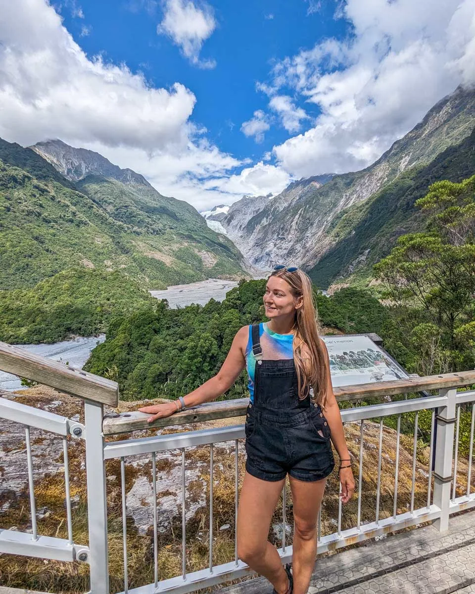
The West Coast is a glacier country. So it’s no wonder many of the best hikes on the South Island’s West Coast include hikes to glaciers. Franz Josef Glacier is arguably the most well-known glacier in NZ, and you can actually hike to the viewpoint of the glacier completely free.
The Franz Josef Glacier Valley Walk is a short 1.7-kilometer (1.1 miles) return trail, that takes around 30 minutes, depending on how long you stay at the viewpoint. The trail is flat, well-maintained, and rated as easy. Along the way, you’ll pass a few waterfalls before eventually arriving at the viewpoint.
It’s worth noting that the trail used to be quite a bit longer, but due to flooding that took out part of the trail, it is now significantly shorter.
Now if you want a truly epic hike, skip the valley walk and instead do a heli hike on the glacier! You’ll ride in a helicopter and land on the glacier before hiking on the glacier for 2.5 hours with your guide. You will actually get to trek across a glacier that is thousands of years old- it’s a simply incredible experience! I still think about this one all the time – you can read my review of the heli-hike here for all the details.
This 4-hour glacier-trekking and helicopter flight is $712 NZD, so while it’s a little pricey, it is worth every cent in my book! You should reserve this tour in advance, as it’s very popular.
27. Fox Glacier Valley Walk

- Overview: It’s not super easy, but the glacier views you get on this hike are epic
- Distance: 3.4 km (2 mi)
- Time needed: 1 – 1.5 hours
- Difficulty: Moderate
- Starts from: Fox Glacier Parking
Only a short drive from Franz Josef Glacier is the Fox Glacier Valley Walk. Both hikes are much the same in terms of the views you get. But the Fox Glacier Track is a little longer and steeper at 3.4 kilometers (2 miles) return and 173 meters (568 feet) in elevation gain.
It’s hard to say which hike is the best. I’ve done both but preferred Franz Josef Glacier. However, since you’re in glacier country, you may as well do both! You can also do the Fox Glacier South Side Walkway/Cycleway if you’re looking for a slightly longer, yet still easy track.
Like Franz Josef Glacier, you can do a heli-hike on Fox Glacier too! This is my top choice for exploring Fox Glacier, as the views and experience from atop a glacier are unmatched. On this 4-hour tour, you will take two 30-minute helicopter rides (for the absolute best views!) and a 3-hour trek on Fox Glacier, led by your expert guide. This experience is $673 NZD, and totally worth it!
Again, this heli-hike is a popular tour, so be sure to reserve it in advance. Exploring the top of an ancient glacier is one of the best things to do in the village of Fox Glacier, which is also worth exploring!
28. Alex Knob Track
- Overview: This track is a treat for experienced hikers with breathtaking views (literally!)
- Distance: 17.2 km (10.7 mi)
- Time needed: 7 hours
- Difficulty: Challenging
- Starts from: Alex Knob Track Trailhead
Both the viewpoint trails above are a great way to see glaciers in New Zealand, especially for the less experienced hiker. But if you’re experienced, then there’s one hike on the South Island that you need to do – Alex Knob Track!
This grueling 17.2-kilometer (10.7 miles) return hike will crush your legs on a journey that takes around 7 hours in total. From the top though, the views of Franz Josef Glacier are pure magic. Seriously, you’ll have your breath taken away (if the hike didn’t do that already)!
You get views that feel similar to a scenic flight, without having to pay for it!
The Alex Knob Track trailhead is just south of Franz Josef Village. You’ll find a decent-sized car park here, but if it’s full you can also park at the main Franz Josef parking lot. I recommend taking off early for this track because there is an afternoon cloud cover that often rolls in, blocking all of the scenic views you worked so hard for!
29. Lake Matheson Walk


- Overview: Grab those amazing reflection photos with this easy hike
- Distance: 20 minutes (40 for the reflection viewpoint!) each way
- Time needed: 4.3 km (2.7 mi)
- Difficulty: Easy
- Starts from: Lake Matheson Parking
Nothing beats an amazing reflection, especially of the mountains. Now add Mount Cook (New Zealand’s tallest) to the equation, and you have yourself one epic view! Lake Matheson is home to the famous photo above that you may have already come across. At sunrise, photographers come to a place called Reflection Island to get that picture-perfect shot.
The hike to Lake Matheson is only around 20 minutes, however, to get to Reflection Island you’ll need to follow the signs and walk another 20 minutes. It’s only one of the many epic views on the hike, so be sure to walk the entire lake trail to see even more!
You can also take a guided hiking tour at Lake Matheson, departing from Franz Josef (which is about 30 minutes away) or Fox Glacier (about 10 minutes away). What I love about this tour is it takes off for sunset, so you get the absolute best views of Lake Matheson’s iconic reflections. The guide will lead you around the loop track and point out other scenic spots, explain about the flora and fauna, and the history of the area. It’s a pretty immersive tour, and you get a nice hike in!
This tour is $95 NZD and can be booked in advance here.
30. Brewster Hut

- Overview: This challenging but short route will test your legs, but the effort is more than worth it
- Distance: 5.3 km (3.3 mi)
- Time needed: 6 hours
- Difficulty: Moderate to challenging
- Starts from: Fantail Falls Car Park
My favorite overnight hike on the West Coast of the South Island is the hike to the Brewster Hut. This short hike takes around 3 hours each way and climbs 1,000 meters (3,281 feet) in elevation over only a few kilometers. It’s steep, and after rain, really slippery!
This trail is 5.3 kilometers (3.3 miles) out and back. That effort doesn’t come unrewarded, though! Even though this is a pretty short trail and can be done in one day, staying at the Brewster Hut is a bucket-list NZ experience!
Once you reach the Brewster Hut you’ll get stunning views of the Southern Alps and New Zealand’s gorgeous West Coast. If you get a clear night, the stars are breathtaking and you can see the Milky Way with the naked eye!
You do need to book the Brewster Hut in advance and there is also a river crossing where the trail starts at Fantail Falls, so be prepared! It is $40 NZD per night to stay in the hut.
31. Truman Track

- Overview: Mysterious caves, stunning beaches, what more could you want from an easy hike?
- Distance: 1.3 km (0.8 mi) round trip
- Time needed: 20 minutes
- Difficulty: Easy
- Starts from: Truman Track Car Park
I did a huge NZ road trip with my mum once and on that trip, we could only do easy hikes as she is definitely not a hiker. One trail I found that we both loved was the Truman Track near Punakaiki. The trail is super short at only 0.65 km (0.4 miles) each way but leads to a stunning beach and some caves to explore. At the beach, you can enjoy the coastline, spot blue penguins, and even find starfish.
You can hike the Truman Track any time of the day, however, to access the beach you need to go at low tide. It’s not recommended to swim as the currents are really strong. So, just take a short walk and enjoy those spectacular West Coast views!
Abel Tasman National Park and Area
32. Abel Tasman Coast Track


- Overview: This multi-day hike is all about gorgeous coastline – you’ll never get bored!
- Distance: 60 km (37.3 mi)
- Time needed: 3 to 5 days
- Difficulty: Easy to moderate
- Starts from: Abel Tasman DOC Car Park
The north of the South Island is home to lots of great hikes with very different landscapes. Instead of mountain peaks, you’ll enjoy beautiful coastal bays, stunning beaches, and even warmer weather. No hiking trail around Abel Tasman National Park is as famous as Abel Tasman Coast Track. This 60-kilometer (37.3 miles) one-way trail is one of New Zealand’s 10 Great Walks.
Because it is a Great Walk, you do have to book the huts and campsites well in advance. However, unlike other Great Walks, you usually don’t have to book Able Tasman Coast Track as far in advance. Huts are $42 NZD per night.
Visitors usually hike the trail over 3 to 5 days depending on how fast they want to go. This an easy-to-intermediate track, so it can really be paced to match your level! And if you’re not up for hiking dozens upon dozens of kilometers, you can break it up into a day hike.
If you have your own transportation, you can take a self-guided day hike. However, if you’re lacking wheels or simply prefer a guided hike option, this full-day hike is my top pick! Departing from Nelson, you will take a boat ride through the gorgeous turquoise waters to reach the part of Abel Tasman Coast Track for a day hike. I love that this tour includes a boat cruise, so you can experience even more of the park.
Along with the hike, the tour guide is a huge asset so you can learn about the national park and its history. You can reserve this tour in advance for $499 NZD and it includes lunch, transportation from Nelson, your guide, and a small group!
You can even add kayaking to your hiking action on this full-day tour! Departing from Mārahau, you will set off on a kayak adventure in the morning (before it gets too hot!) and then take off on your hike. There is truly so much of Abel Tasman National Park to explore, so this kayak and hike tour is the perfect way to do it. This tour includes transportation from Mārahau, lunch, and kayak equipment
You can book this full-day tour for $190 NZD!
There are lots of other Abel Tasman tours that include a hiking option, from multi-day tours to skydiving tours- there is something for everyone here!
Related Read: While in the area, be sure to check out all the fun things to do in Nelson and the cute town of Motuka!
33. Queen Charlotte Track

- Overview: Full of epic viewpoints, this multi-day hike is full to the brim with epic beaches, bays, and more
- Distance: 72 km (44.7 mi)
- Time needed: 4 days
- Difficulty: Moderate
- Starts from: Ship Cove Queen Charlotte Trailhead
To the east of Abel Tasman National Park near the town of Picton (where the ferry between the North and South Islands operates) is another famous multi-day hike called Queen Charlotte Track. Queen Charlotte Track navigates part of the Marlborough Sounds (a must-visit place in NZ) along a 72-kilometer (44.7 miles) track that takes around 4 days to walk.
It’s most common to begin Queen Charlotte Track in Ship Cove (the furthest point from Picton) and walk towards Anakiwa. Along the way, you’ll visit similar landscapes as Abel Tasman National Park which includes beaches, bays, and greenery like you’ve never seen before!
Bookings also have to be made in advance for this trail to spend the night, especially for the summer hiking season. However, it’s nowhere near as busy as other hiking trails in the area such as Abel Tasman Coast Track.
There are a handful of day hikes you can take on the Queen Charlotte Track, ranging in length and difficulty. This self-guided hiking tour makes planning easier, as it provides a water taxi to the three most popular trails (Ship Cove, Endeavor Inlet, or Torea Bay) and will pick you up at the end. This makes experiencing just a piece of the Queen Charlotte Track a breeze, so it’s totally worth $96 NZD! I recommend booking this tour in advance to ensure your spot.
You can also just explore the Queen Charlotte Sound on this kayaking tour where you’ll learn about the history and see sheltered coves and remote beaches. Keep your eye out for eagle rays, cormorants, little blue penguins, New Zealand fur seals, and dolphins in the waters! You’ll meet at the Picton Waterfront to meet your local guide and get the kayak equipment, then have 4 hours of paddling and exploring in one of the prettiest places ever! You can reserve this kayak tour for $110 NZD.
You won’t be disappointed regardless of how you experience the Queen Charlotte Track and Sound, whether it’s hiking the full track, a portion, or kayaking. It’s all beautiful!
Hikes in the Catlins/Southland
34. Koropuku Falls

- Overview: The ideal introduction to the Catlins – short, sweet, and so much fun!
- Distance: 26 km (16.2 mi)
- Time needed: 30 mins
- Difficulty: Easy
- Starts from: Koropuku Falls Trailhead
If you weren’t planning on visiting the Catlins, you likely will after reading this. The region is filled with stunning waterfalls and my personal favorite is Koropuku Falls. Although getting to the falls is more of a South Island walk rather than a hike, I just had to include it – I love it that much!
You’ll find the trailhead along Chaslands Highway 26 kilometers (16.2 miles) from the small town of Tokanui. It’s hard to find, so punch it in on Google Maps so you don’t miss it! Once parked on the side of the road (be careful), it’s a short 15-minute walk along a creek to the falls. The trail is never busy, and often you’ll have this place to yourself.
At the falls, just admire the view – it’s stunning! This is a super short hike, but this is one of those hidden hikes on the South Island that you surely won’t want to miss!
35. Slope Point Walk

- Overview: See the southernmost point of New Zealand’s South Island here on this easy trail!
- Distance: 2 km (1.2 mi)
- Time needed: 20 to 30 minutes
- Difficulty: Easy
- Starts from: Slope Point Parking
Slope Point is the southernmost point on New Zealand’s South Island. It’s also a beautiful coastal region where rough seas crash upon steep cliffs with little protection from the wind. It’s a wild place to visit, and while you’re there, you can take a photo with the sign so you can prove that you’ve been to the southernmost point of New Zealand’s South Island!
The walk to Slope Point is only 1 kilometer (0.6 miles) each way and although short, the views at the end make it one of the best hikes on the South Island.
36. Mclean Falls Track

- Overview: Waterfalls galore on this short but fun trail in the Catlins region!
- Distance: 2 km (1.2 mi)
- Time needed: 30 minutes
- Difficulty: Easy
- Starts from: McLean Falls Parking
Another short hike in the Catlins region is the walk to McLean Falls. It’s only a 1-kilometer (0.6 miles) walk to the falls from the parking lot, so although not much of a hike, it’s one of the most incredible waterfalls in New Zealand. The only reason I love Koropuku more is because McLean can get very busy during the day.
The trail follows a river, where you’ll find lots of other small waterfalls along the way. But that’s just the start, the true attraction is the huge McLean Falls. I love getting long exposure shots of the falls, it’s just so magical!
37. Rakiura Track
- Overview: A gorgeous island hike that’s actually the best place to spot a wild kiwi!
- Distance: 32 km (19.9 mi)
- Time needed: 2 to 3 days
- Difficulty: Moderate
- Starts from: Rakiura Track Trailhead
The last Great Walk on this list of the best hikes on the South Island is called Rakiura Track. The trail is actually located on Stewart Island which involves taking a short ferry ride from the South Island. This stunning island is actually the best place in New Zealand to spot a wild kiwi and you’ll likely see one on Rakiura Track.
Because of the trail’s remote location, it is free of predators which means it’s also one of the best places in NZ for bird watching. On the track, you can spot species such as shags, dotterel, kaka, and even blue penguins.
Rakiura Track is a 32-kilometer (19.9 miles) loop and you can hike it in 2 to 3 days camping or staying in huts along the way. Bookings do need to be made in advance, but the trail is much less popular than other Great Walks.
After you take the ferry, you can take a scenic 2.5-hour catamaran tour departing from Stewart Island to get a feel for it. Again, you’ll likely see some incredible bird life, as well as fur seals and various types of penguins, all while learning about the area from your naturalist guide. You can reserve this tour in advance for $119 NZD.
Since this tour is short and sweet, you can add it to the beginning or end of your Rakiura Track exploration, I’m sure you won’t get tired of the incredible views as you take on this South Island hike!
Christchurch and Arthur’s Pass
38. Godley Head Loop Track


- Overview: A beautiful walk near Christchurch – keep an eye out for seals and more!
- Distance: 9.3 km (5.8 mi)
- Time needed: 3 hours
- Difficulty: Easy to moderate
- Starts from: Godley Head Loop Track Car Park
Located just on the outskirts of Christchurch there is a really beautiful coastal track called the Godley Head Loop Track.
Following the coastline, the Godley Head Loop is a 9.3-kilometer (5.8 miles) track that takes around 3 hours to walk. Along the way, enjoy views of Lyttelton Harbour, and be sure to keep an eye out for seals, dolphins, and even whales!
This is my favorite hike near Christchurch, and just goes to show that even in a New Zealand city, you’re not far from nature! It makes for an excellent day trip from Christchurch!
39. Devil’s Punchball Walking Track


- Overview: See one of my favorite waterfalls in NZ on this short hike
- Distance: 1.9 km (1.2 mi)
- Time needed: 40 minutes
- Difficulty: Easy
- Starts from: Devil’s Punchbowl Car Park
Want to visit the most ferocious waterfall in New Zealand? Then be sure to drive Arthur’s Pass and hike the Devil’s Punchball Walking Track. The name alone should get you excited but if that doesn’t, then the fact it’s a 131-meter tall (430 feet) waterfall should!
The trail to the falls is short and sweet with a small elevation gain that takes around 20 minutes each way. Once there you’ll be amazed at the falls and might even get a little wet. Regardless, this waterfall is epic and a popular stop for anybody driving from Christchurch to Hokitika.
One of the most popular ways to experience Arthur’s Pass is to take the TranzAlpine Train from Christchurch. This is known as one of the most scenic train rides in the world, and it’s right at your doorstep!
This tour is unique because you’ll take the train there, and then be driven back to Christchurch, stopping at scenic locations along the way. One of those scenic locations is the Devil’s Punchbowl, so this is a 2-for-1 type of tour! There will be other stops as well, such as Otira Viaduct Lookout and Arthur’s Pass Village. It’s a whole day of scenic views for $450 NZD and includes your train ticket, transportation, lunch, afternoon tea, and a guide- you really don’t have to plan anything.
While hiking the Devils Punchbowl Walking Track is certainly one of the best hikes on the South Island, pairing it with the TranzAlpine Train makes this experience even better! Book this tour in advance here.
40. Avalanche Peak


- Overview: This trail has some serious elevation gain, but with it comes those incredible views!
- Distance: 6 km (3.7 mi)
- Time needed: 5 to 6 hours
- Difficulty: Moderate to challenging
- Starts from: Devil’s Punchbowl Car Park
Avalanche Peak is the best hiking trail on Arthurs Pass. By no means is this 6-kilometer (3.7 miles) trail easy, in fact, most people take 5 to 6 hours to walk the 6 kilometers (3.7 miles)! The reason? The steep terrain and huge elevation gain of over 1,110 meters (3,642 feet). For those who do, get to witness arguably the best panoramic view of the Southern Alps, seriously!
Avalanche Peak sits at 1,833 meters (6,014 feet) above sea level and the trek up can actually be dangerous if you’re not experienced or prepared. Please do not attempt this hike in high winds, winter, or rain!
Related Read: Check out my blog about the best hikes on the North Island for even more adventure!
Renting a Car, Campervan, or Motorhome in New Zealand


Let’s face it, you’re going to need wheels to get around New Zealand. Although a small country, buses between destinations are infrequent and expensive. Plus, some of the best experiences you can have in NZ are on road trips!
You have three options when it comes to getting wheels in New Zealand: a car, a campervan, or a motorhome. Here’s what you need to know about each and where to get them:

Car
A normal car is the cheapest rental vehicle you can get in New Zealand. It’ll get you around to all of the best destinations with ease. The only downside to a car is that you will need to stay in hotels or Airbnbs during your travels (no camping, unless you buy a tent!). My favorite place to rent a car in New Zealand is Snap Rentals. They are a local company that offers affordable and high-quality rental vehicles across the country. Plus, I have an exclusive discount that gets you 10% off when you book through this link or use the code MQD10 at checkout! And if you can’t find what you’re looking for on Snap Rentals, check out Discover Cars, where you can compare cars and prices across many different companies.

Campervan
A Campervan is a large van that has a bed and a small kitchen in the back. It’s what most budget travelers use for traveling around New Zealand since it allows you to camp comfortably and for free (most) nights. Campervans are best for couples or solo travelers who are happy to live in a small space. You should also love the outdoors and camping…and be prepared for an adventure of a lifetime! My favorite campervan rental company is JUCY because they have a huge selection of campervans to choose from, plus multiple pick-up/drop-off locations. You can browse JUCY’s campervan selection online here. Alternatively, you can easily compare all campervans available in NZ on Motorhome Republic here.

Motorhome
A motorhome is larger and more comfortable than a campervan. Many motorhomes will comfortably sleep 6 or more people – perfect for a family visiting New Zealand. Motorhomes are the most expensive option, but with one, you won’t ever need to stay in a hotel, and you’ll save money that way. My top choice for a motorhome company is Star RV because they have beautiful motorhomes at affordable prices. You can check prices and availability for Star RV motorhomes online here. Alternatively, you can use Motorhome Republic to search all motorhomes in NZ. For more detailed info, read my complete guide to renting a motorhome in New Zealand!
EXCLUSIVE DISCOUNT CODE: I’ve organized a special discount code that will get you up to 10% off if you book your campervan or motorhome through JUCY or Star RV!
Simply click here to select your JUCY campervan, or click here to select your Star RV motorhome, and then use the code DTRAVEL10 at checkout to get 10% off bookings with travel dates up to and including September 30, 2026 (minimum 5-day hire). Traveling outside those dates? No worries—use code DTRAVEL25 to receive 5% off anytime through December 31, 2026 – it’s that easy!
AIRALO e-SIM Up To 15% Off With Code “DTRAVEL15”
What’s an eSIM?
An eSIM is a digital version of a SIM card. Instead of buying a little plastic chip and swapping it into your phone, you just download it. It connects your phone to a local network in whatever country you’re visiting — no stores, no waiting, and no fiddling with tiny cards.
In simple terms, it’s the easiest way to get data and stay connected while traveling.
We’ve tested a bunch of eSIMs in North America, and after a few frustrating experiences, we’ve found our favorite — Airalo. It’s fast, reliable, and incredibly easy to use. You can set it up in minutes (even my mom managed it solo on her first try!), and the prices are some of the best out there.
🔥 Hot Tip: Choose the Oceania-wide eSIM! It works across 8 countries, so you can hop from New Zealand to Australia to Fiji without ever losing connection. One download, endless adventures.
Bonus: We’ve got an exclusive 15% discount for our readers. Use the codes:
Thanks for reading!

The South Island of New Zealand is one of the best places in the world to go hiking! Looking back, I can’t believe just how many trails I’ve done, and can’t wait to explore many more soon!
For you, though, this list is a great start to choosing what trails you want to do on the South Island. There’s no right or wrong answer for which ones to choose, and one thing I promise is that you’ll love them all!
Thanks so much for reading my guide to the best hikes on New Zealand’s South Island. If you loved this blog, then browse around, My Queenstown Diary is filled with awesome guides about Queenstown and the surrounding area! Here are some of my most popular guides:
12 Best Places for Helicopter Tours in New Zealand
18 Best CHEAP Things to do in Queenstown
10 EPIC South Island Road Trips You’ll Love in New Zealand
Let me HELP you plan your road trip!
I’ve created this FREE e-book that is your COMPLETE GUIDE to planning a road trip in NZ! In the guide, you’ll find many different road trip itinerary ideas, so you can easily choose one that works for you!
The guide includes the best stops, attractions, road trip routes, and how much time you need!


Fantastic stories and beautiful experience. Thanks.
I did almost all of tracks and reading your stories I had refreshed my memory.
Keep writing ,you are very talented writer.
Kind regards Milomir
Hey Milomir!
Wow, you’ve done a lot of great hikes! What hikes haven’t you done and are you planning on doing them!?
Thank you! I have been very busy writing!
Thanks
Bailey
Wow, what a great article By the Way i am Farooq Nice information dear Thanks for sharing!
Hey Farooq!
Glad you liked the blog
Happy travels.
Bailey
Hi Bailey,
Thanks so much for this beautiful summary! I’m planning a trip to the South Island in January and was feeling a little demoralised after realising in September that I was perhaps a little late to the party if I wanted to book one of the Great Walks. Found some great alternatives in your list here to help plump up the itinerary and it gave me hope that I still might be able to complete some sort of exciting overnight or multi-day hike for an added sense of holiday achievement! Keen to flick through your other posts for more ideas. 🙂
Thanks and best wishes,
Hannah
Hey Hannah!
Don’t worry at all! I love the Great Walks, but there is so much more to see! I myself have no bookings this summer either. Instead, I’m going to explore more hidden trails to share. The best thing about some of the other trails, is they’re far less crowded.
Enjoy your trip!
Bailey
THANK YOU FOR YOUR TIME TO DO THIS LIST !!!!1
No worries!